
"The City as a Landscape" by Gina Ford

Humanity has been conditioned to see cities as fixed, as knowable, and as built. Traditional maps of cities use lines and shapes to mark and hold space, signifying roads and buildings. Natural systems are often represented lightly, and more often they are the non-made, leftover, or remnant. Traditional maps for places like Salt Lake City, Utah; Sarasota, Florida; and Detroit, Michigan do not hint at the vast differences in character, topography, and identity between these places. By virtue of their prioritization of systems made by humans, they become abstract representations of place, which, in turn, often becomes the de facto starting point for planning or design projects.

The role of landscape architects and planners in an era of large-scale climate change can be, in part, as ambassadors of a new way of seeing the city. Storytelling and visual representation of the “City as a Landscape” can offer a transformed understanding of the dynamism of place.
Building this understanding with communities is a major driver of the work we do at my firm, Agency Landscape + Planning. Our work spans regional planning to site design and construction, advocating for a design process of co-creation with community. We see engagement as a two-way exchange: we are transformed through the feedback and education the community provides, and we hope to equally transform community members into advocates and stewards of the outcomes of a given planning or design process.
In our part of this two-way exchange, we strive to create images that awaken a new awareness of the uniqueness of a given place. To begin, we seek to express the city by way of its underlying geomorphology. Our position is that the ecological foundation of a place is not just a historic condition, or one outside the city limits, but rather the most critical lens to understand its contemporary condition and to establish the appropriate scale or frame for all decision-making.
To demonstrate this approach, we began our work in Salt Lake City, Sarasota, and Detroit by diagramming and exploring each city as both place and process informed by ecological terms: Salt Lake City as a “Valley,” Sarasota as an “Edge,” and Detroit as a “Matrix.” This framework provided a richer and more expansive lens to understand the climate conditions impacting each city.
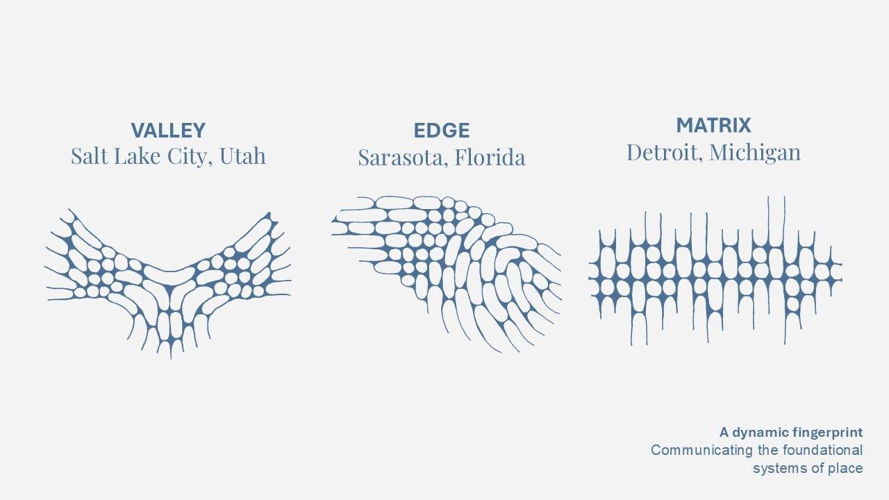
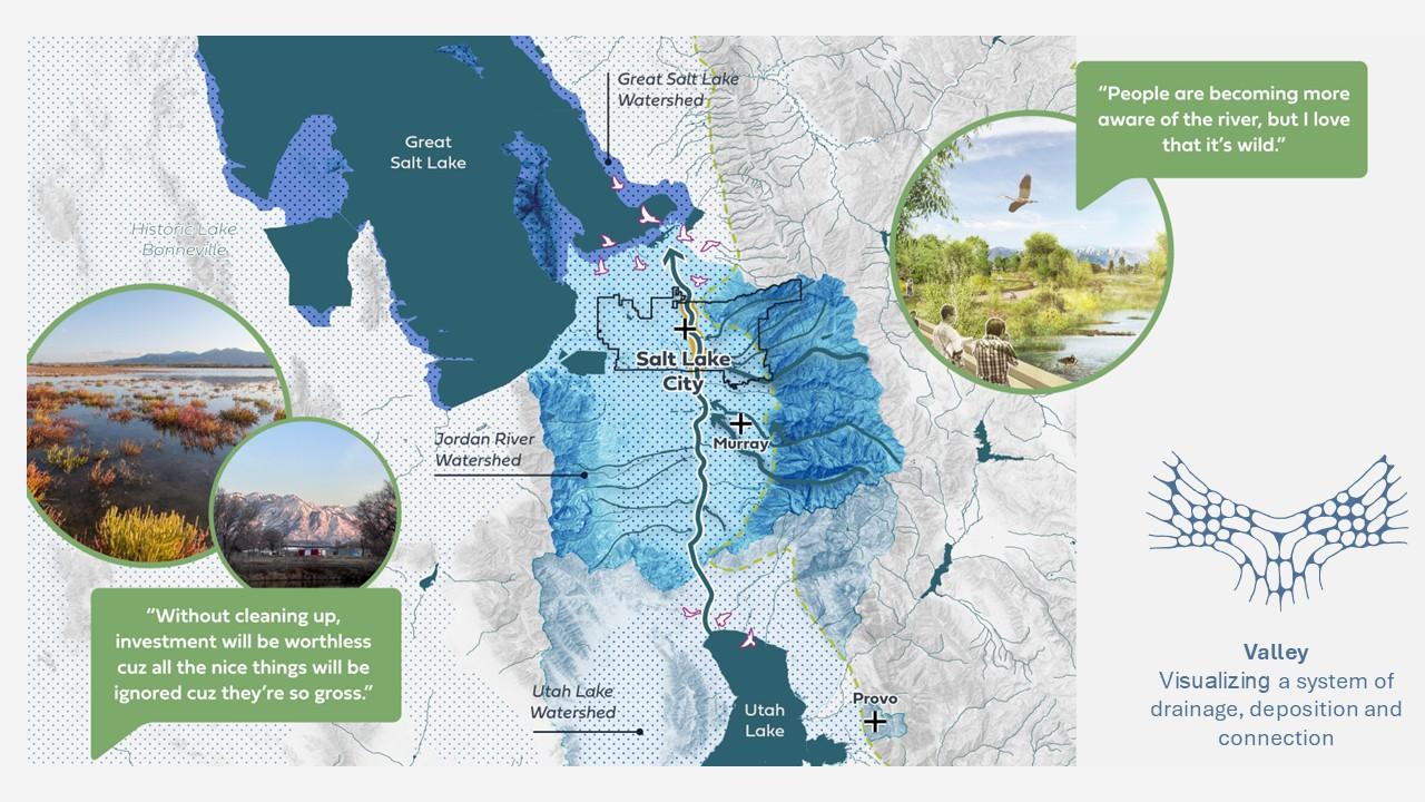
THE VALLEY: SALT LAKE CITY, UTAH
Working with Austin-based ecologists Siglo Group on a nine-mile stretch of the Jordan River, we created a vision plan dubbed “The Emerald Ribbon.” The Jordan River is the ecological heart of the Salt Lake Valley, connecting some of the most socially vulnerable communities in the city. Flowing 44 miles from Utah Lake in the south to the Great Salt Lake in the north, the river is a vital waterway in the Salt Lake Valley that has supported robust wetlands and wildlife for millennia.
In ecological terms, a “Valley” is a low-lying landform between hills or mountains shaped by erosion from rivers or glaciers that acts as a natural corridor and habitat. They influence local climate and support fertile soil and water resources. As a "Valley,” the Jordan River receives the urban runoff from much of the city proper and is a critical link in a much larger ecological system threatened by water degradation and evaporation. Agency Landscape + Planning’s work linked the community’s perception of a degraded river with a broad scale look at the larger ecological setting. Our mantra on this project was nature—culture—care, which sought to center the maintenance of the landscape as key to both local and regional experience. The drawings expressed the concept of “Valley” at multiple scales using a regional view of the city and its context as well as the detailed scale of the river itself.
The Emerald Ribbon Action Plan builds on the foundational belief that if we care for nature’s ecological health, nature will engage and sustain human well-being. At the center of this intertwined relationship is a system of care. Salt Lake City's diverse Westside community has watched a once-vibrant river corridor struggle under the weight of growing public safety concerns, under-maintained amenities, and poor water quality. This plan puts forth a proposal deeply rooted in the dreams and aspirations of that community to steward and enliven an Emerald Ribbon that meets its full potential as the heart of the Westside and the vibrant ecological counterpoint to the mountains to the east.
THE EDGE: SARASOTA, FLORIDA
The City of Sarasota, Florida, is perched on the western edge of the state and the eastern edge of the great Gulf of Mexico. The Bay is a 53-acre site being transformed into a resilient, welcoming, and signature waterfront park for the community of Sarasota.
Ecologically, an “Edge” is the boundary between two distinct habitats, such as the moment a forest meets a grassland. This transition zone, also called an ecotone, is a unique area that can support a mix of species from both adjacent habitats, or even a community of its own. As an “Edge,” The Bay serves a role in protecting the city from the water by being a first line of defense in the increasingly frequent hurricane and storm surge events of the region. The Bay also plays a major role in protecting the water from the city by being the last line of defense before the Bay for urban runoff originating from the city. With this context in mind, every feature of The Bay is designed with a sensitivity to environmental processes and sustainability. The Bay’s design offers innovation across various water systems: not only do the rain gardens, denitrification trenches, and large-scale infrastructure systems capture, hold, and treat water locally, but they also work together to treat over 70 million gallons of stormwater passing through annually from off-site.
Before The Bay’s creation, the site discharged 300 million gallons of urban runoff directly into Sarasota Bay each year, carrying pollutants, nutrients, and debris that damage underwater habitats. The park now employs a “treatment train” system: runoff from adjacent roads and neighborhoods is routed through a sequence of constructed wetlands, rain gardens, and stormwater ponds that remove silt and pollutants before water enters the bay. Phase 1 treats 70 million gallons each year, while the completed park will purify all 300 million gallons of on- and off-site runoff traversing the property.
The Bay also acts as protective green infrastructure for the city, buffering the site’s coastal vulnerability from storm events. New natural shorelines are designed to accommodate occasional flooding and absorb storm surges, using nature-based solutions to improve resilience to extreme weather. Elevated structures and permeable boardwalks protect sensitive terrain by allowing sunlight to reach the substrate and minimize compaction. Most recently, the site sustained and withstood a direct hit from Hurricane Milton in 2024, an early test of the design’s resilience for future events.

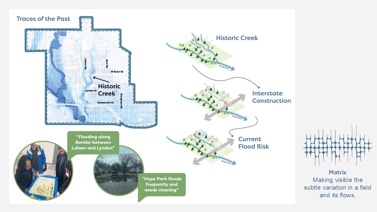
THE MATRIX: DETROIT, MICHIGAN
The City of Detroit, Michigan is a classic Midwest city—a vast grid within a relatively flat landscape of open prairie and lake edge. The city is implementing a series of neighborhood plans to help reposition communities for future decades, including the work led by Agency for the Brightmoor Area.
A "Matrix" in ecological terms refers to the most extensive and connected background landscape element in a habitat that surrounds patches of different ecosystems. It can also refer to a grid-like table used in assessments to map the relationships between project activities and environmental impacts. As a “Matrix,” Detroit and the Brightmoor neighborhood are challenged by the lack of porosity of urbanized development in a largely flat and undifferentiated ground plane.
The Brightmoor neighborhood is built on a former creek that remains invisible today outside of storm events. This placement leads to major stormwater challenges, including frequent street and basement flooding that is likely to worsen due to climate change. With exponential growth over the last century, expansion of the relentless grid and housing developments supporting rapid industrialization erased the creeks of the Brightmoor neighborhood. In the center of Brightmoor, the worst flooding still occurs along the historic creek, which was once part of a tributary to the Rouge River. In addition, highway construction nearby serves as a dam to the natural flow of the tributary, making flooding worse by preventing proper drainage. As a result, many places and streets flood frequently during small and large weather events alike.
Early in the process, our work sought to reveal this historic condition, showing the community how underlying geomorphology shapes today’s challenges. Residents understood the alignment of flood-prone areas to the historic creeks and why large sections of land became vacant over time.
This framing and understanding of the neighborhood's unique ecological conditions offered a way forward with design recommendations, particularly regarding future stormwater solutions. Vacant spaces became places for parks and open spaces, offering sites for green infrastructure, stormwater retention, and filtration wetlands to manage rainwater during heavy storms. During dry periods, these spaces would function as parks, providing environmental benefits and recreational opportunities. Our approach helps mitigate flooding, enhances resilience to future storms, improves water quality in the Rouge River, and creates sustainable public spaces.
As environmental change becomes more dramatic, more frequent, and more damaging, landscape architects have the skills to envision the city as a landscape: a living, breathing and dynamic system of processes and change. We help communities understand the reasons why change happens and how they will experience such change. Perhaps most importantly, we create design solutions that address this change and enlist the community in making it positive, impactful, and lasting.
Gina Ford (FASLA) is a landscape architect, co-founder and principal of Agency Landscape + Planning. Underpinning her nearly three decades of practice are a commitment to the design and planning of public places and the perpetuation of the value of landscape architecture via thought leadership, teaching, writing and lecturing. Her work has received awards from the American Society of Landscape Architects, the American Planning Association and the American Institute of Architects, among others. She is on the board of directors for the City Parks Alliance and the stewardship council of The Cultural Landscape Foundation. She received the Harvard Graduate School of Design’s Charles Eliot Traveling Fellowship, the Wellesley College’s Shaw Fellowship and the Boston Society of Architect’s Women in Design Award of Excellence.

This article is part of a series of essays exploring topics inspired by “Landscape First” hosted at The University of Texas at Austin in the spring of 2025 with the generous support of the Still Water Foundation. All opinions, views, and provocations expressed are solely those of the authors and do not represent the official positions, policies, or perspectives of the School of Architecture.
READ THE ENTIRE LANDSCAPE FIRST ESSAY SERIES HERE →